
Maps of Australia dating back to 1910 reveal alarming weather pattern

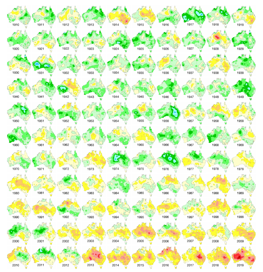
A diagram showing more than a century of average temperatures released by the Bureau of Meteorology shows an alarming trend in Australia’s weather.
BOM released diagrams showing the 12-month mean temperature for Australia for every year since 1910.
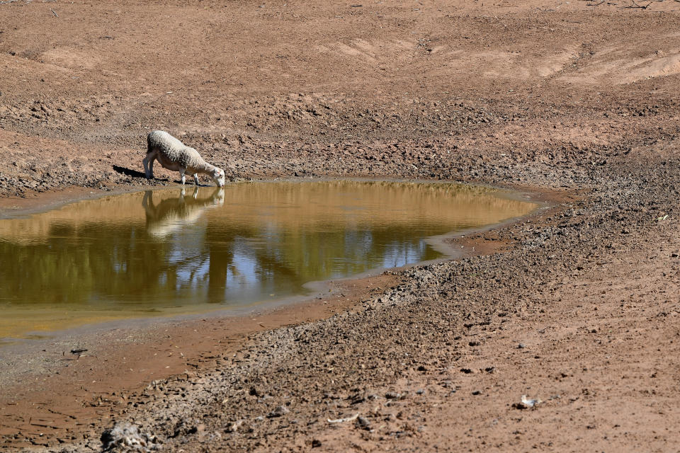
It shows that after a string of hot years 2019 was especially hot, and was the country’s driest and hottest year on record.
According to BOM, 2019 was 1.52 degrees above average - surpassing the record of 1.33 above average in 2013.
Bureau of Meteorology head of climate monitoring, Dr Karl Braganza, said January, 2019 “was the warmest month Australia has ever recorded” while last month “saw the Australia-wide record hottest daily average maximum temperature broken multiple days in a row”.
Why was Australia so hot in 2019?
"Most of this year, Australia's climate has been dominated by a very strong positive Indian Ocean Dipole, which acted to both warm and dry Australia's landscape, particularly from around the middle of the year,” Dr Braganza said.
"We also saw the influence of a rare Sudden Stratospheric Warming event high above the south pole, which acted to push our weather systems northward and compound the warmer and drier than average conditions over southern Queensland and NSW during spring, amplifying the fire weather.
"The other key factor at play is that Australia's climate has warmed by more than a degree since 1910, which means very warm years like 2019 are now more likely to occur, while the trend in recent decades has been for drier winter and spring seasons in the south."
In December, Australia hit its highest average maximum day-time temperature at 41.9. It broke the record on two consecutive days.
The highest temperature recorded that week was 47.7 at Birdsville Airport in Queensland.
While Adelaide recorded a top of 45 degrees in Kent Town and Sydney reached a top of 42.5.
Temperatures exceeded 45 degrees for much of the interior of Australia. At Ceduna on the west coast of the Eyre Peninsula in South Australia a maximum of 46.5 degrees was recorded.
Much of the east coast and parts of South Australia have also been ravaged by bushfires.

What is in store for Australia’s weather in 2020?
Hot temperatures have continued into 2020.
On January 4, Penrith set a new record for the hottest temperature in the Sydney basin when it reached 48.9. On the same day Canberra recored 44, its hottest day on record.
BOM’s head of long-range forecasts, Dr Andrew Watkins, told reporters on Thursday patterns over the Southern and Indian oceans are “starting to break down”.
“So, we’re heading back to some more neutral climate drivers and that means that our rainfall and our temperatures hopefully will start to ease back towards a bit more of a normal pattern,” he said.
Dr Watkins added it will remain warm “for a while yet” due to soil temperature along with warm offshore oceans.

However, he expects rainfall patterns to go back to average.
“Unfortunately, we’re not looking at widespread above average rainfall at this stage and that’s really what we need to put the fires out fairly quickly,” Dr Watkins said.
“We’re not looking at a short and sharp end to the event. It does look like something we’ll have to persist with for some time.”

There’s been some rainfall this week to assist in putting out the blazes but most areas haven’t seen significant totals.
Cooma near the NSW Snowy Mountains received 5mm over the past week while Batemans Bay received just 1.8.
Orbost in Victoria’s East Gippsland didn’t receive any rain at all while most areas around Adelaide received 5mm or less.
Dr Watkins told Yahoo News Australia on Thursday unfortunately it’s appropriate to consider the upcoming change more as being “less dry”, rather than being “more wet”.
When did Australia last have above average rainfall?
Dr Watkins said Australia last saw “significant” above average rainfall in 2010 and 2011.
He compared it to floods and rainfall the country experienced in the early 1970s.
“So, it still can rain in Australia if we get the right climate drivers but unfortunately of late we’ve had climate drivers push us towards dry and warm rather than towards the cooler and wetter,” he said.
Tropical Cyclone Blake and the tropical low to Australia's north have both developed into a monsoon trough.
It may hit Darwin next week.
No significant rain expected for months
Dr Watkins said there’s a “smallish chance” a monsoon or tropical cyclone could head into the southern parts of the country.
“It can happen. In general though, the climate isn’t looking like it will see a significant above average rainfall over wide areas at least for several months,” he said.
He added it may take until autumn to see any changes in rainfall.
Will January 2020 be hotter than January 2019?
Dr Watkins said the odds “are not great” for it to be a record breaking January in 2020.
“It’d be a little bit of a surprise to us,” he said.
“But things have been so extreme I don’t think we can discount anything.”

Do you have a story tip? Email: newsroomau@yahoonews.com.
You can also follow us on Facebook, Instagram and Twitter and download the Yahoo News app from the App Store or Google Play.


